Kannur
Introduction
:
Kannur's days of glory were
under the Kolathiri Rajas, and its importance as a spice trading
port was noted by Marco Polo.
From the 15th century various colonial powers, including the
Portuguese, Dutch and British, exerted their influence over
this rich Malabar Coast region. Most of the Kannur's sites
are a few kms out of town.
Places
to see at Kannur :
Payyambalam Beach :
Payyambalam beach is one of the most beautiful beaches in
Kerala. Here rest the brave nationalist and political leaders
like Swadeshabhimani K. Ramakrishna pilla, A.K.G. and Chadayan
Govindan. This is two kms away from Kannur town and near the
St. Angelos Fort. This beach, having laterite rock jutting
out into the sea on one end, is a neat and long one which
is a relief to the tourists who seek rest away from the modern
city life.
As part of a targeted comprehensive
tourism development, this natural beauty spot is fast changing
into a tourist center of international standard. It is the
famous sculptor and the State Tourism Advisory Committee member,
Shri Kanai KunjiRaman who is imaginatively beautifying Payyambalam.
In the park attached to the beach, he is preparing a beautiful
piece of sculpture, “ a mother with a child lying facing
the sea”. this structure has a 80 feet length and 15
feet height. The landscaping of the park is over. The construction
of other pieces of art is also going on. The models of folk
arts of Malabar including Theyyam are being prepared.
A park for the children
also is being arranged here. The aim is to make arrangements
to attract children for amusement and exercise. The Payyambalam
canal will be widened and deepened without delay for the pleasure
boating of the children. A footpath has been brick-laid between
the guesthouse and the lighthouse from where sunset can be
enjoyed and the beauty of Dharmadom Island towards the south
and the headquarters of Ezhimala Navel Academy towards the
north can be seen.
Dharmadam Island :
This small Island which is situated in the sea like a green
spot just 100 m away from shore, becomes a blissful experience
to tourists. This isle is full of coconut trees. There is
only a well here as the symbol of human presence. One can
reach this place by boat from southern part of Moithu bridge
in the national highway. During ebb time one can reach here
by foot. From this isle one can see the rocks around and the
beauty of Muzhuppilangad beach and the distant beauty of Thalassery
town. When Dharmadam isle was an important trading center,
this isle was in the possession of Chirakkal king. Later it
passed into the hands of the English and now it is in the
hands of private individuals.
Muzhuppilangad Beach :
It has a length of 4.5 kms. The special feature of this beach
is that the vehicles can be driven without getting stuck into
the sea sand. This is why the beach is considered to be the
only drive in beach in the State. This beach which extends
from Muzhuppilangad to Moithu Bridge is considered as swimmers’
paradise since there are no waves in this part due to the
rocks here and there and the sea is not deep. This beach is
15 kms away from Kannur in the south direction and 8 kms away
from Thalassery in the north direction. A tourist can reach
this beach through five panchayat roads starting from the
National Highway. The transportation to this beach will be
improved as the coastal road is completed. In order to turn
this beach into a drive in beach and arrange water sport facilities
through exploiting to the maximum the natural specialties
there, the District Tourism Promotion Council has chalked
out projects and they are being implemented. Children’s
park and huts to enjoy the natural beauty of Dharmadam Isle
have been constructed. Steps have been taken to identify the
safe places for sea bath and illuminations. Facilities like
cafeteria and toilet will be provided
Parassinikkadavu Temple :
It is a famous temple in south India. It is situated 20 kms
away from Kannur. It is famous for its natural beauty. Boating
facilities are available for tourists.
Thalassery Fort :
This fort which had witnessed many ebbs and tides of history
is of much importance to tourists who are interested in historical
events.
The fort is situated in
the Thiruvallippad hill of Thalassery town, 20 kms away from
Kannur in the south direction. It was constructed by the British
East India Company in the year 1708. this fort has to tell
many stories of the victory and defeat of Kalathiri, Tippu
Sultan and Pazhassi Raja.
This fort is built of red
bricks in an area of two acres. The British used this frt
as a jail and currency manufactory. It was here that the leader
of the Hyder Ali’s army was imprisoned and the death
bed of Swathi Thirunal’s successor was arranged. Thalassery
silver coins were also minted here. St. John’s Church
is nearby this fort. Here rests Edward Brennen who contributed
significantly to the cultural and educational fields of Thalassery.
As such this place has assumed the prominence of a pilgrim
center.
PaithalMala :
It is 44 kms away from Thaliparampu and 4500 feet above the
sea leve. These huge mountains lay spread over 500 acres of
land. This is a dense forest area. One can go by bus upto
Pottanplavu. From there jeep can be driven for six kms. After
that, 2 km walk by foot. North of Paithalmala is Kudaku forest.
At the base of the mountain, a tourist information center
and dormitory have been constructed.
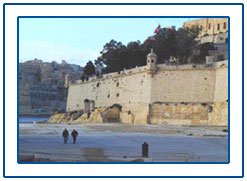
Fort St. Angelo :
Facing the sea, this is one of the most attractive centers
in Kannur district. It is also known as Kannur Fort. This
fort is 3 kms away from Kannur town in the western direction.
The fort stands close by the Arabian Sea. This fort proclaims
the strength and beauty of Portuguese architecture. The two
sides of the fort facing the sea was built in a triangular
shape. It was Don Francisco De Almeida, the first Portuguese
Viceroy, who laid the foundation stone of this fort with the
permission of Kolathiris in 23 October 1505.
The Dutch captured the fort
in 1663 and sold it to the Ali Raja of Kannur in 1772 and
in 1790-it came into the possession of the British. This fort
is now under the control of Archaeological Survey of India.
The Arabian Sea, the dense
coconut trees, the fishing boats and natural harbor moppila
bay are the unforgettable sights, one can have from this fort.
Arakkal kettu of historical importance can also be seen from
this fort. Different projects are being implemented at the
government level to preserve the fort in a good condition.
Projects envisage to beautify the fort retaining its antiguity
and providing parking area.
Travel Information :
Kannur is on the main north-south
route for trains and buses. You can go by bus or train from
all points on the coast. There is a direct bus to Mysore.
Kannur is a major railway
station on Shornur-Mangalore line. By road Kannur is 155 kms.
south of Mangalore and 92 kms. north of Kozhikode. The nearest
airport is at Calicut which is 115 kms. south. The Mangalore
airport is 170 kms. north of Kannur. Its 324 kilometres from
Bangalore.

|