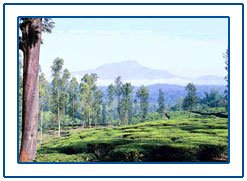
Wayanad
Introduction :
Comprising an area of 2126
sq. kilometers, Wayanad has a powerful history. Historians
are of the view that organised human life existed in these
parts, at least ten centuries before Christ. Countless evidences
about New Stone Age civilization can be seen on the hills
of Wayanad. The two caves of Ampukuthimala located between
Sultan Bathery and Ambalavayal, with pictures painted on their
walls and pictorial writings, speak volumes of the bygone
era and civilization.
Recorded history of this district is available from the 18th
century. In ancient times, this land was ruled by Rajas of
the Veda tribe. In later days Wayanad came under the rule
of the Pazhassi Rajahs of Kottayam royal dynasty. When Hyder
Ali became the ruler of Mysore, he invaded Wayanad and brought
it under his sway.
Travel Attraction :
Banasura Sagar Dam :
This is the largest earth dam in India. The topography here
is such that many islands will be formed in the upstream of
the dam when the dam is full. These islands with the background
of the Banasura hill will provide a hypnotizing sight to tourists.
Chembra Peak :
The hills, rocks and valleys which contribute to the very
unique character of Wayanad provide a lot for adventure tourism.
Trekking to the Chembra peak is a risky mountaineering endeavor.
Chembra peak, the highest hill in Wayanad, is near Meppady
town. Trekking to the top of this peak takes almost a day.
Tourists can also stay one or two days at the top of the peak
in temporary camps. District tourism Promotion Council provides
guides, sleeping bags, canvases, huts and trekking implements
on hire. The scenic beauty of Wayanad, which is visible from
the top of Chembra, is very exhilarating.
Edakkal Cave :
This location of breath taking beauty is three kilometers
from Ambalavayal which is 25kms from Kalpetta.
The Edakkal cave in the
Ambukuthy mountain is not a cave in the real sense. As stated
in the India Antiquary and quoted in the district Gazetteer,
Kozhikode, it is only 'a cleft about 96ft. long and 22ft.
wide in the rock'. It is a fissure made by a corner of rock
splitting off from the main body due to some natural causes.
The depth of both the cleft and fissure is 30ft. What makes
it a cave to the ordinary observer is the fact that in the
other portion of the large cleft, an enormous rock, weighing
several tones, has fallen forming a roof over a large part
of it. The rock wall contains some interesting carvings, which
represent human and animal figures and objects of human use
and symbols. These carvings speak of a highly civilized people
of pre-historic age and inspires the archeologists and historians
to rewrite the history of Wayanad and Kerala as a whole.
Kuruva
Island :
The Kuruva island, 950 acre3s of ever green forest on the
tributaries of east flowing river Kabani, is an ideal picnic
spot, far away from the disturbances of city life. The island
is uninhabited. Rare species of birds, orchids and herbs are
the sovereigns of this supernal kingdom. It is 17kilometers
east of Mananathavady and 40kms north west of Sulthan Bathery.
Lakkidi
:
One of the highest locations in Wayanad, Lakkidi also commands
a picturesque scenery. It is about 58kms north east of Kozhikode
and 5kms south of Vythiri. Lakkidi, the gateway of Wayanad,
lies atop Thamarassery, a ghat pass at an elevation of 700m.
above mean sea level.
The lofty mountain peaks,
the gurging stream, luxuriant vegetation and the birds eye
view of the deep valley on the south, with its winding roads,
are breath taking. The 12kms long journey from Adivaram to
Lakkidi through ghat road with nine hairpin bends amidst thick
forests, is a fascinating experience.
Pakshipathalam
:
Pakshipathalam in the Brahmagiri hills at Thirunelli, is a
challenging tourist spot for any adventure seeking tourist.
To reach Pakshipathalam seventeen kilometers have to be covered
through wild forest. The deep rock caves, formed among the
thick blocks of rocks at the northern top end of Brahmagiri,
are the abode of various birds and wild beasts. Special permission
has to be obtained from Forest Department to go to Pakshipathalam.
District Tourism Promotion Council arranges vehicle, guides,
camping equipments, etc. to the tourists, on hire.
Pookot
Lake :
It is a natural fresh water lake, brimmed with evergreen mountains.
The weather here is salacious; the scenic beauty, hypnotizing
and the nature, unspoiled. Pookot Lake tourist resort in Vythiri
is the most sort after tourist spot of Wayanad. The is an
aquarium and a green house here. Boating facilities also are
available. Spices and handicraft items are also arranged for
sale at Pookot. The lake has an area of 8.5ha. and maximum
water depth is 6.5m. This lake is 3kms south of Vythiri.
Travel
Information :
Air
:
Nearest airport is Karippur ( Kozhikode)
Rail
& Road :
Railway facility is not available at Wayanad. The nearest
railway station is at Kozhikode, about 70kms. from Kalpetta.
The only mode of transport of goods and commuters within the
district is roadways. Bus services are available in all panchayats.
Though there is no national high way touching Wayanad, the
district has a network of roads.

|